Anti UAV-LW-I Type Anti-Drone System
In response to the increasingly serious drone threat, the company has independently developed the Anti UAV-LW-I anti-drone system. In addition to basic functions such as anti-drone detection, lateral, deception, suppression, etc., it can also be configured according to different users and different application scenarios to support secondary development.

Anti-UAV-LW-I anti-drone system adopts specific amplitude direction finding technology, which can provide electronic fence function based on GPS position information deception. It has a 70MHz~ 6GHz broadband signal monitoring function (factory default is ISM2.4GHz & 5.8GHz band). After monitoring the drone signal, calculate the drone azimuth angle, and send simulated no-fly zone navigation signals in the corresponding angle orientation, deceive and interfere with the drone navigation position information, making it impossible to approach; the system can operate unattended 24H, and identify, direction finding and area rejection of the drone by itself after starting up and running, and can upload the alarm information to the control center through the network port or data transmission station, of which navigation deception is an optional function.
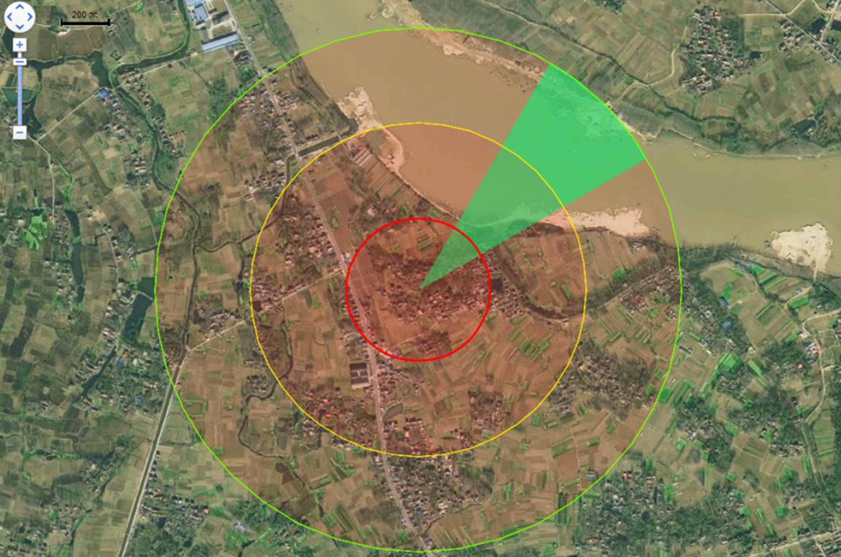
The drone monitoring interface can visually display the drone's orientation on the map, and upload and save early warning information. When the system is working in manual mode, the system will report early warning information including drone model, invasion time, and azimuth angle, and the staff on duty will carry out the next operation. When the system is working in automatic countermeasure mode (with navigation deception function module), the system will send simulated navigation signals according to the direction of the drone, and drive the drone away.

Anti UAV-LW-I basic model includes functions and technical specifications:
basic function | implementation method |
Drone identification | Model recognition based on radio signal characteristics, providing feature library input interface |
drone direction finding | Amplitude direction finding, accuracy 5 degrees |
Technical indicators
Identifiable frequency range | 10MHz—6GHz | real-time detection bandwidth | 160MHz |
detection angle | 360˚ | Antenna polarization method | circular polarization |
effective direction finding distance | ≥5km | direction finding accuracy | ≤ 5°(RMS) |
Protection class | IP66 | Power consumption of the whole machine | ≤80W |
weight | 8.6kg | size | Diameter 490mm, Height 250mm |
Optional accessories and features
option function | Function Description | Remarks |
navigation deception | GPS L1, GLONASS L1 dual-mode navigation signal simulation, can guide the drone to fly away, circle or forced landing. | |
Communication link interference (directional) | Full-band power suppression (single 30W) is carried out on the remote control-image transmission link, and a directional antenna distribution station is used, with a range of 2km. | |
Communication link interference (omnidirectional) | The remote control-image transmission link is subject to full-band and omnidirectional power suppression (single-channel 50W), with a range of 1.5km. | |
narrowband interference | A 200M bandwidth high-speed signal processing board is used to track the remote frequency hopping signal in real time and suppress it in narrow band. | Provide a hardware platform for collaborative development |